The phrase ‘storm of the century’ is an overused term that gets bandied about during many storms of unusual intensity. It’s natural to consider the big storm that happens to the current generation as the granddaddy of them all. Some call it chronological snobbery — the arrogant belief that what happens to this generation is more important than what’s happened in the past.
The Great White River flood of November 1906 really was the storm of the century. It resulted in catastrophic flooding that forever changed the course of a mighty river and altered the drainage patterns of the central Puget Sound region between Seattle and Tacoma. The long valley stretching from Renton to Puyallup would never be the same.
During the first two weeks of November 1906, more than six inches of rain fell in the Cascade Mountains between Snoqualmie Pass and Mount Rainier. On the evening of November 13, the barometer dropped precipitously, resulting in high winds, followed by 2.5” of rain over the next 24 hours. Snow that accumulated in October melted as temperatures reached the high 50s. The downpour, coupled with melting snow, raced off the mountain slopes. The combined deluge sent both the Green and White Rivers to historic levels. The rushing floodwater created massive logjams of fallen trees, strewn lumber, houses, barns, livestock, and household items that cascaded downstream.
Bridges, railroad tracks, and power lines were washed out or swept aside. All train traffic was halted due to the flood. Those watching from higher outposts saw nothing but a sea of water encompassing the common valley shared by Puyallup, Sumner, Auburn, Kent, and Renton. Trapped residents signaled for help from the roofs of their homes. By the next day, the White River flowed directly into the Stuck River on its way to Tacoma. On November 15, 1906, the White River divorced itself from King County’s watershed for good. It would never again follow its traditional route, joining the Green River to become the Duwamish and meander into Seattle’s Elliot Bay.
After the high waters subsided, flood control meetings were held to flesh out solutions. A flood committee was established, and Major Hiran Chittenden of the U.S. Army Corps of Engineers was tasked with studying the problem to find remedies. He acknowledged that the White River historically belonged to King County. But Chittenden’s report concluded, “Nature has transferred the course, and it will be simpler to perpetuate it than to change it again.” As an engineer, he saw the pragmatic nature of the solution: “The distance to the sea by the Duwamish route is about 40 miles; that by the Puyallup is only 20 miles. The slope by the shorter route is much greater than by the longer route, and the same quantity of water can be carried in a smaller channel.”
Five years later, Hiram Chittenden commanded the construction of the Ballard Locks that connected a lowered Lake Washington to the Puget Sound. Those impressive locks bear his name.
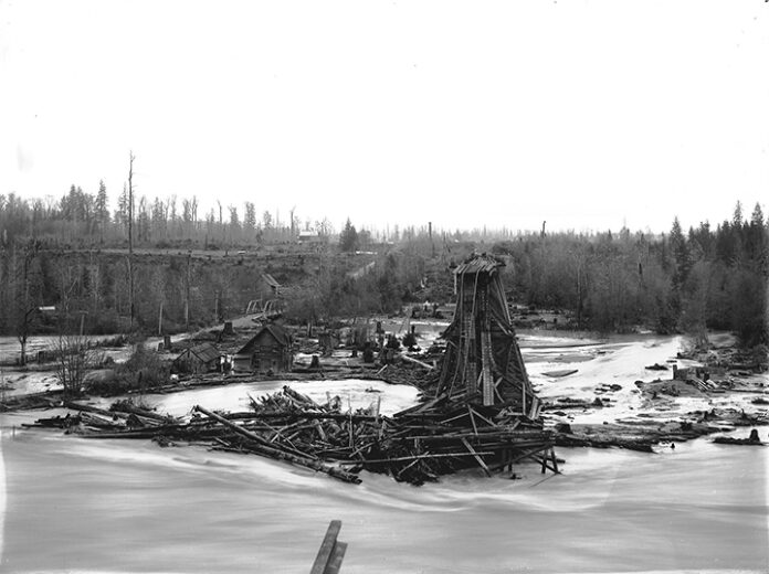
Further upstream between Enumclaw and Buckley, the Northern Pacific Railway trestle was seriously damaged by the November 1906 flood, as seen in this photograph taken shortly after the initial catastrophe. Collected debris piled up below the trestle, and steel rails are seen hanging down to the river’s edge.
To the left of this photo, which faces Enumclaw, is the first White River Bridge, part of the planned Naches to Yakima highway. That bridge was first built in 1897, then lost in a 1908 flood. The Old Buckley Bridge eventually succeeded it, as featured in this column three weeks ago. Two houses are visible between the flooded road and the railroad trestle. Boise Creek can be faintly seen between the two bridges, where it drops 70 feet from the Enumclaw Plateau to the White River channel.
This photo #2009.5-144 by Karl Jensen comes courtesy of the Enumclaw Plateau Historical Museum. Additional information about the November 1906 flood was obtained from Mike Sato’s 1997 book, “The Price of Taming a River.”


