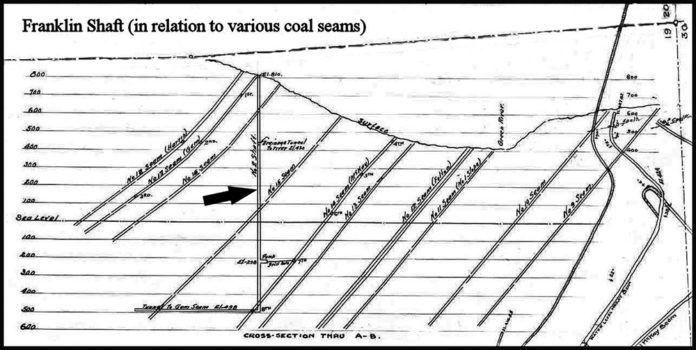
A map makes a poor photograph but presents a fascinating picture of the world of coal mining. This side view of a slice of earth has an arrow pointing to a vertical hole in the ground, which is 1,300 feet deep. This Saturday you can actually stand upon a metal grate over that 11’ x 18’ rectangular column dug nearly 120 years ago. It’s called Franklin Shaft No. 2 and it’s one of the highlights of the twice-yearly Franklin tours conducted by the Black Diamond Historical Society. In the fall of 1900, Pacific Coast Coal Co. commenced ambitious plans to sink a shaft to access more coal in the Franklin field. Its purpose was to intersect additional coal seams (the diagonal openings on the above map) at ever lower depths allowing production to expand. The company’s intent was to make their Franklin mines one of the state’s biggest producers.
It’s said that, ‘best-laid plans of mice and men often go awry’ is doubly true in a coal mine. The shaft was completed in 1903, but ironically never used as intended. Following abandonment the shaft was covered with large timbers to prevent access. In the 1950s, railroad iron was added above the rotting timber. In 1984, the Office of Surface Mining installed heavy-duty wire screen encased in concrete and surrounded by guard rails to secure the opening yet still allow safe viewing. A bronze plague presents a brief history. On the first Saturday of March and April, the Black Diamond Historical Society conducts annual walking tours of the historic coal mining town of Franklin. If interested, meet at 10 a.m. in the Black Diamond Museum, 32627 Railroad Avenue, to register and hear an orientation. Participants should wear sturdy shoes and dress for the weather as the tour goes on rain or shine.


