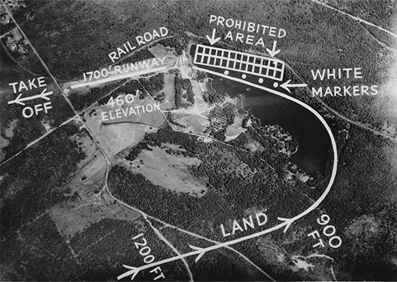
Last week’s column featured a bird’s eye view of Gaffney’s Lake Wilderness Lodge when the airstrip was in operation. According to an article by Irving Petite in the Sept. 1952 issue of Flying, “The 2,400-foot airstrip, adjacent to a luxurious $300,000 lodge is one of the reasons why Washingtonians enjoy their light-plane flying.” The magazine promoted small airplanes adding, “This wilderness is within easy reach for weekend vacationers whose highway is the sky.” The article provided further details: “Air taxi service to Gaffney’s airport is available by calling the Bellevue Air Field. They will pick up passengers at either of the large airports and fly them into the resort. Rates charged by these insured carriers are: one person, $10; two persons, $15; and three persons $18.85. The maximum load is 550 pounds and service is between sunrise and sunset.”
The origin and date of this aerial photo with superimposed flight directions is unknown. It was likely provided to pilots flying single engine planes in and out of the airfield. The current Witte Road roundabout is below and to the right of the letter F in “Take Off.” However, the Flying magazine claim of a 2,400-foot airstrip is contradicted by the flight directions whose runway length shows 1,700 feet. Given a 2,000-feet east-west distance between the lodge and Witte Road, the 1,700-foot length is accurate. The Lake Wilderness airport began operations around 1950, the year the lodge was completed. It closed about 1960. Today, the former airstrip comprises a portion of the Arboretum which is part of the 117-acre Lake Wilderness Park. Adjacent to the park is the 96-acre Lake Wilderness Golf Course. Originally designed by Ray Coleman, it opened in 1929 as a 9-hole course where holes 15 through 18 are located today. That golf course area was around the “460’ Elevation” lettering.


